Physical Science
PHYS 1040 - Elementary Astronomy
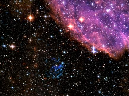
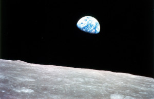
Astronomy has had a great impact on my life this semester. Although studying was sometime daunting, I always felt great while doing assignments because I learned so much in the process. A lot of the information in this course coincided with what I was learning in Natural Disasters. Being that they are both physical science courses, that was to be expected. This course has changed my life and the way I look at things around me. The universe is so vast, but the particles that form everything therein are so microscopic. I really enjoyed learning about the creation of life and elements and how everything begins in the core of a star.
This paper demonstrates that I am able to carry out well-versed and educational conversations with friends in a relaxed manner. I have learned so much in this course and I am always happy to share that knowledge with any curious party. This assignment made me realize how much I have progressed throughout the course of this class. My last memory of learning about the solar system was in elementary school. I am happy that I have taken so much away from astronomy and this assignment ultimately made me realize how much I have learned this semester.
GEOG 1700 - Natural Disasters

|
Astronomy Conversation Final Paper.pdf Size : 170.855 Kb Type : pdf |
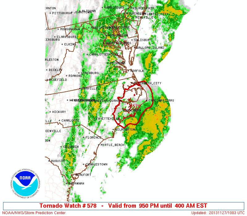
 URGENT - IMMEDIATE BROADCAST REQUESTED
   TORNADO WATCH NUMBER 578
   NWS STORM PREDICTION CENTER NORMAN OK
   950 PM EST TUE NOV 26 2013

   THE NWS STORM PREDICTION CENTER HAS ISSUED A

   * TORNADO WATCH FOR PORTIONS OF
     EASTERN NORTH CAROLINA
     COASTAL WATERS

   * EFFECTIVE THIS TUESDAY NIGHT AND WEDNESDAY MORNING FROM 950 PM
     UNTIL 400 AM EST.

   * PRIMARY THREATS INCLUDE...
     SEVERAL TORNADOES POSSIBLE
     A FEW DAMAGING WIND GUSTS TO 70 MPH POSSIBLE

   THE TORNADO WATCH AREA IS APPROXIMATELY ALONG AND 55 STATUTE
   MILES EAST AND WEST OF A LINE FROM 25 MILES SOUTHEAST OF
   JACKSONVILLE NORTH CAROLINA TO 90 MILES NORTHEAST OF NEW BERN
   NORTH CAROLINA.  FOR A COMPLETE DEPICTION OF THE WATCH SEE THE
   ASSOCIATED WATCH OUTLINE UPDATE (WOUS64 KWNS WOU8).

   PRECAUTIONARY/PREPAREDNESS ACTIONS...

   REMEMBER...A TORNADO WATCH MEANS CONDITIONS ARE FAVORABLE FOR
   TORNADOES AND SEVERE THUNDERSTORMS IN AND CLOSE TO THE WATCH
   AREA. PERSONS IN THESE AREAS SHOULD BE ON THE LOOKOUT FOR
   THREATENING WEATHER CONDITIONS AND LISTEN FOR LATER STATEMENTS
   AND POSSIBLE WARNINGS.

   &&

   OTHER WATCH INFORMATION...CONTINUE...WW 576...WW 577...

   DISCUSSION...DEEP CONVECTION AND INITIALLY NIL TO MRGL SFC-BASED
   BUOYANCY EACH IS FCST TO INCREASE GRADUALLY OVER NEXT FEW
   HOURS...AMIDST FAVORABLY LARGE LOW-LEVEL HODOGRAPHS AND DEEP SHEAR.
   ACTIVITY MAY INCLUDE SUPERCELLS AND SMALL BOWS...OFFERING BOTH
   TORNADO AND WIND-DAMAGE RISK.  REF SPC MESOSCALE DISCUSSION 2049 FOR
   FURTHER/INITIAL NEAR-TERM DETAILS.

   AVIATION...TORNADOES AND A FEW SEVERE THUNDERSTORMS WITH HAIL
   SURFACE AND ALOFT TO 0.5 INCH. EXTREME TURBULENCE AND SURFACE
   WIND GUSTS TO 60 KNOTS. A FEW CUMULONIMBI WITH MAXIMUM TOPS TO
   450. MEAN STORM MOTION VECTOR 23035.

|
SPC Watch.gif Size : 72.938 Kb Type : gif |
|
|
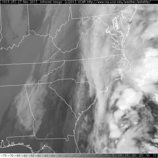
Infrared Image.jpg Size : 43.274 Kb Type : jpg |
|
|
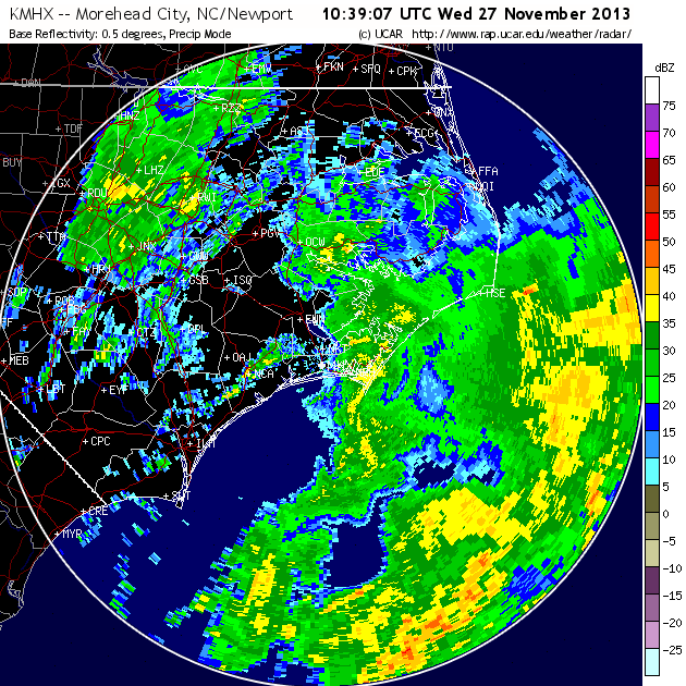
Doppler.png Size : 118.902 Kb Type : png |
Analysis of Tornado Watch
As of November 27, 2013, this tornado watch, number 578, was in effect and its target, Eastern North Carolina. Primary threats include several tornadoes and wind gusts up to 70 mph. In terms of hurricanes, wind gusts that strong almost reach the minimum requirement of 74 mph on the Saffir-Simpson Hurricane Scale.
Severe thunderstorms are at high risk in these weather conditions. The formation of severe thunderstorms are reliant on such conditions as large fluctuations in wind shear, high water-vapor content in the lower troposphere, updraft of air, and the existence of dry air mass above moist air mass. (Natural Hazards)[1] With this tornado watch forming over the Atlantic Ocean, there is plenty of water content in the lower troposphere, which is the atmospheric level closest to the Earth.
A tornado watch is just a precautionary measure to alert people of the potential of severe weather concerns. It’s not until the tornado has been sensed by weather radar that it can be upgraded to a warning. A warning means that the area at risk is indeed in danger and should take all precautionary measures to ensure safety.
A tornado usually forms from a severe thunderstorm. The vertical wind shear causes a rotation to form in a thunderstorm. Updrafts then cause the cumulonimbus cloud to lower part of itself in the form of a funnel that is called a wall cloud. Once that spinning funnel touches the ground, it is deemed a tornado. Moist air is drawn upward to form a visible condensation funnel. When upward-spiraling air meets downward drafts, the tornado begins to move about in an erratic way at speeds reaching 60 mph, for several minutes.
Visible imagery is produced by reflected sunlight and is only available during daylight. Since I live in a time zone currently six hours ahead of North Carolina I have not included a visible image in this tornado watch. This watch also ends at 4:00 am, before the sun comes up. A visible image senses reflected solar radiation from clouds, the atmosphere, and the surface of the earth, whereas infrared images sense re-emitted solar radiation. In other words, infrared images sense the heat being emitted from clouds, the atmosphere, and the surface of the earth after they have absorbed some of the radiation from the Sun.
In the accompanying Doppler radar image, I believe that clean air mode was used, because the scale is in dBZ. Doppler radar antennas send electromagnetic radiation that is reflected by objects in the sky, like raindrops and clouds. The wavelength of the waves reflected by these objects changes pending on whether they are moving toward or away from the antennas.
This Doppler image shows that the waves reflected by objects and returned to the antenna are between 5-50 on the dBZ scale. This implies that if that mass of yellow hits North Carolina, it’s going to bring with it a torrential-downpour. The part of the image showing a rating of 50 on the dBZ scale means that there is heightened reflectivity by objects in the sky in that section, denoting that there is a lot of precipitation activity.
This assignment was really interesting. It’s rewarding to take something I have read about in a book throughout the semester and relate it to a real-life scenario that is happening as I speak. I’m glad we have the technology to sense storms before they make landfall. The Earth is a fascinating place filled with amazing and devastating natural occurrences. Since we cannot stop them from occurring, it’s nice to know that technology has allowed us to properly prepare for the grimmest of situations.
[1] Taken from Natural Hazards Third Edition, Keller & DeVecchio, published by Pearson Education Inc., 2012, New Jersey.
Reflection
Analyzing images of weather conditions can be interesting and fun. In the assignment I selected, I had to decipher what a Doppler image of a tornado watch over North Carolina was telling us. In the past when I have watched the weather, I always wondered what the different colors in images meant. I learned that there are two modes when imaging weather patterns with Doppler radar, clear air mode and precipitation mode.
Each mode has their perks and work best under different circumstances. Learning the scale that the clean air mode imaging is measured by was really cool. From black to white, black being no activity and white being the most severe, I have finally learned what weather forecasts are showing when they use Doppler radar images.
Programs like Google Earth are changing the way people look at not only the planet, but also the ocean and space. The amount of money and technology that goes into aerial photography programs is astonishing. It’s awesome that most of these programs come at no cost to the public. Sadly, a lot of people do not know they exist, or if they know they exist, they don’t know the extent of what they can do.
Recently, Google Maps launched programs to gain information about worlds under the sea and in faraway galaxies. There is still a lot that must be done to make these programs highly functional, but who doesn’t want to know more about strange, unknown worlds?
One concern that people may pose in response to this upwelling of technology, is their right to privacy. Google Earth sends imaging cars around the world to take stills of neighborhoods for their assortment of programs, but occasionally a person will end up in a photo. They do their best to blur faces, but for some people that is not enough.
I personally think that the good outweighs the bad in this scenario. Google Earth is providing the world with an amazing gift, where we can take vacations and adventures to places that people rarely have the chance to go.